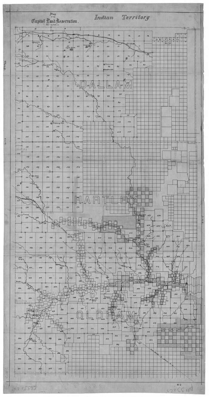
During the closing years of the 1870s, vast areas of public lands owned by the State of Texas remained underutilized and their value unrealized as the state exited the Reconstruction period. With the adoption of the Constitution of 1876, this asset became the focus of state efforts to develop public works. This Constitution provided for the appropriation of 3 million acres of the public domain to fund the construction of a new state Capitol, a story that many Texans know well. A lesser-known aspect of this history entails the controversies that complicated the survey project that initiated the transformation of 3 million acres of state land into the largest ranch in the world. Led by contractor Joseph Theodore “J.T.” Munson in 1879 and 1880, the survey of what became the Capitol Land Reservation employed expert surveyors like John S. Summerfield and H. A. Wiley in the Panhandle to produce an intricate record of the vast property. A detailed survey was created, but it attracted intense legal scrutiny as potentially fraudulent practices by the firm of Gunter & Munson in Sherman came to light. More problems emerged in subsequent years as more accurate surveys uncovered significant errors in Munson’s survey that affected landowners in the region as late as the 1920s.
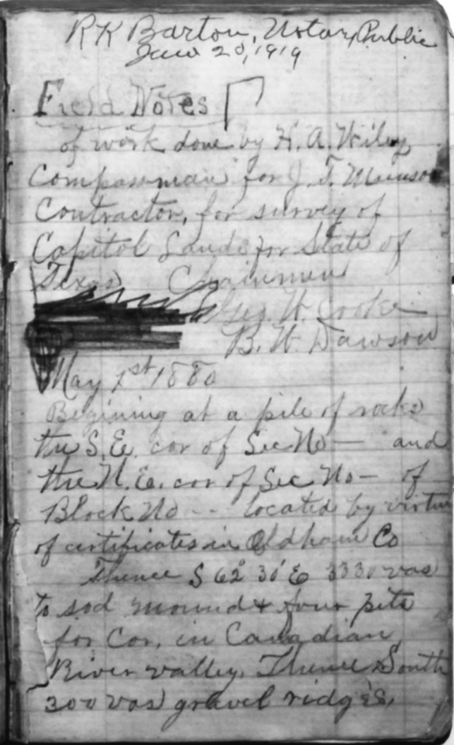
Texans and others fascinated with Texas history have a wealth of information available to them from repositories across the state. From public and private universities to state agencies, the preserved records documenting the state’s history are voluminous. Fortunately, while not all of these have been or will be digitized, many repositories have online collections that offer access to their records. The Texas General Land Office (GLO) is one such entity. Most of their maps, land patents, and related ephemera can be found online. Among these are survey records of the land development that impacted Texas, including a document titled “Current Miscellaneous File 9.” The online description is rather ordinary, showing an image of a photocopy of a handwritten document. The expanded subtitle for this file offers more clarity: “Copy of field notes of work done by H. A. Wiley, compass man for J.T. Munson,” with the additional information that it is part of a “Supreme Court of Texas” file in support of the “case of G. Findlay et al plaintiffs in error vs. The State of Texas regarding Capitol Lands.” The descriptive metadata also indicates that the file belongs in the General Map Collection. Most map records from the GLO contain information about the item’s geographical scope, but this information is absent. Even the date of its publication is missing. Thankfully, two words of the subtitle lead researchers to the main topic of the file: Capitol Lands.1 With this information, it is possible to track down the original document, which is housed at the Texas State Library and Archives Commission in their Texas Supreme Court archives.2 (Fig. 2)
Courtesy of the Texas State Library and Archives Commission
The term “Capitol Lands” is synonymous with the XIT Ranch of the Texas Panhandle, but what relationship does this document have with that enterprise? As noted previously, the Texas Constitution of 1876 reserved 3 million acres of vacant land to fund the construction of a new Capitol building.3 Three years later, the Sixteenth Legislature acted on this mandate by officially setting aside land in several Panhandle counties, including Bailey, Castro, Cochran, Dallam, Deaf Smith, Hartley, Hockley, Lamb, Oldham, and Parmer counties.4 The legislators added 50,000 acres to their appropriation to fund a survey. The act was approved on February 20, 1879, with officials soliciting bids to survey the land in April. Newspaper advertisements appeared all over the state, with bidders given a deadline of May 15, 1879. According to one in the Galveston Daily News, bidders had to submit two estimates. The first estimate would cover the cost of the survey, assuming the successful contractor paid all his expenses, while the second estimate detailed the cost of the survey at a per-mile rate, with the successful contractor funding two surveyors and the state covering the expenses for chain carriers, assistants, and supplies.5
Twenty bids were submitted from across Texas, with others coming from states such as Iowa and Missouri.6 Francis F. Hopp, a civil engineer, surveyor, and eventual county attorney from Matagorda County, received the contract just one day after the bidding period closed.7 Hopp submitted a bid of $5,999 for “the work done and completed at the expense of the bidder and contractor.” He also submitted a bid of $1.24 per mile with the state covering the expense of providing assistants and chain carriers. The Commissioner of the GLO, William C. Walsh, sent Hopp notice of his successful bid on May 16, 1879. Hopp swiftly responded by writing to Walsh on May 21 and to Texas Attorney General George McCormick on May 27. In his letters, Hopp appeared eager and willing to supply the necessary bond to secure the contract, stating that it would be “forwarded to you at the earliest time possible.”8 But sometime between May 31 and June 14, Hopp surrendered the contract. The circumstances of this surrender are unclear, but Hopp was likely unable to meet the bond requirement.9
Courtesy of the Grayson College Foundation, Portal to Texas History, University of North Texas
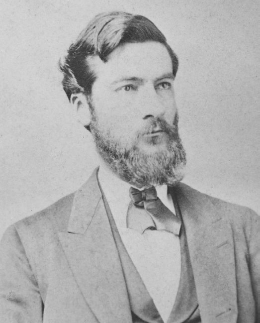
The next lowest bid was submitted by Munson, a real estate dealer from Denison, Texas (Fig. 3). His bid totaled $7,440 and $1.25 per mile under the same guidelines as other bids. Commissioner Walsh notified Munson on June 14, 1879, sending a letter to his brother’s office in Sherman. This brother, William Benjamin “W. B.” Munson, and Jonathan “Jot” Gunter worked together as successful land agents in Sherman who platted and sold land in the Panhandle, including tracts that would eventually abut the Capitol Land Reservation. The partnership of Gunter & Munson was very familiar with the Panhandle as it had been working in the region since the conclusion of the Red River War in 1875. And they had done well. A brief examination of grantee information on land blocks in the northern Panhandle shows the Gunter & Munson moniker near several prominent watercourses.10
J.T. Munson, with the assistance of his brother’s company, began assembling a survey team to leave Denison for the Panhandle by July 20, 1879. His bond for the contract went to Walsh on July 12.11 The Gunter & Munson firm, although not officially part of the contract to survey the lands, contacted two surveyors, hoping to employ them for the survey work. The first was Summerfield, an independent surveyor for the firm’s holdings in the Panhandle. A June 30 letter to Summerfield gave him specific instructions for the project. J.T. Munson would initially take charge of the surveying crews already in the field, while Summerfield would supervise the bulk of the work as Munson planned to return to Denison shortly after starting the survey. John Baird “J.B.” Quigley of St. Louis, Missouri, was hired as the other surveyor. Quigley’s relation to Gunter & Munson is unclear, but he agreed to be paid $300 for four months of surveying work.12
Along with appointing a lead contractor for the surveying project, the State Capitol Board — the governor, comptroller, treasurer, attorney general, and GLO commissioner — were required to appoint a commissioner to ensure all the instructions given to the contractor were followed. They were also responsible for choosing the specific lands to be surveyed from the remaining public domain. The board initially turned to Walter P. Lane for this role. Lane had previously served in the armies of the Republic of Texas, the United States, and the Confederacy, fighting in the Texas Revolution, the Mexican-American War, and the American Civil War. He received notice of his appointment from Gov. Oran M. Roberts on May 17, 1879. Lane was a well-known figure in Texas, and an article in Marshall’s Tri Weekly Herald lauded the choice. By the late 1870s, he had retreated from the public eye but had fallen on hard times financially and was eager to return to state service. He had sought several roles within the government, including an unsuccessful bid to be the adjutant general. In informing Lane that he had been appointed, Roberts stated, “I offer it to you first of all, though there are many applicants, as a testimonial of my respect and confidence in your capacity and integrity in a matter of great interest to the State.” On July 10, Roberts sent Lane his commission with the responsibilities and duties he was expected to follow.13 Two days later, Lane resigned due to his inability to submit a required $300 bond. He had visited the Gunter & Munson firm on July 10 or 11 to notify them of his resignation. A biographer of Lane also indicates that he was displeased with J.T. Munson’s attitude. Munson knew the Panhandle well and informed Lane that the land to be surveyed might not be as valuable as the state hoped. Given the impression that he might not be fully reimbursed for his work, Lane chose to resign before starting.14
Needing to identify a reputable replacement, the State Capitol Board and Governor Roberts chose Nimrod Lindsay “N. L.” Norton of Salado. Norton, like Lane, was a well-known figure in Texas, having been a leader and founding member of the Texas Grange in 1873 and the founder of several county fair associations. This role would take him as far as becoming the General Superintendent of the Capital State Fair Association. A Kentucky native and later a Missouri congressman for the Confederacy, Norton had come to Texas in 1871. He quickly built a reputation as an accomplished agriculturalist as he assembled an extensive set of powerful allies through connections and efforts. With his experience in evaluating agricultural outputs and prospects in Central Texas, Norton proved to be a valuable asset to the State Capitol Board in selecting the best possible land to raise funds for the construction of the new Texas Capitol. J.T. Munson learned of Norton’s appointment in a July 17 letter from Roberts.15
J.T. Munson left Denison for Sherman on July 20, 1879. In acquiring his supplies, he was instructed not to buy too much in Denison or Sherman, for goods such as flour could be bought in Tascosa, in the Panhandle county of Oldham, at similar prices.16 Jot Gunter joined Munson as he traveled west with his team. Gunter was uniquely familiar with the Panhandle, having spent significant time in the field evaluating land for his business. The group traveled to Fort Worth to employ several other men before leaving for Fort Elliot on July 24. Munson established his base of operations in Tascosa. One of few settlements in the western Panhandle at that time, it offered the surveying team a centralized outpost of civilization while working on the plains. The exact route the party took is unclear, but it is known that they stopped in Clarendon enroute to Tascosa. Summerfield, as the Gunter & Munson surveyor already active in the Panhandle, was well known in that community and joined Munson there as he trekked westward.17
The top responsibility of Commissioner Norton was to direct the surveyors where to begin and to ensure that the land surveyed met the criteria set by the enabling legislation. Their survey was to connect to nearby tracts already patented, and “worthless” land was to be excluded if possible. This primarily meant avoiding rocky, sandy, or barren property that would not be of value in any planned sales. The survey crew, including Norton, would be responsible for noting the quality of the land surveyed, especially the quality of the soil, grass, timber, and proximity to water. Since Norton did not receive his commission until around July 15, he arrived in Tascosa several days after Munson’s survey began. Norton’s first note to Roberts from the Panhandle, dated September 10, 1879, detailed his late arrival while also notifying the Governor that work had commenced and that the league numbering would begin at the northwest corner of Texas in Dallam County.18 Although unknown to the group in 1879, this was not the true northwestern corner of Texas as defined by the juncture of the north boundary of the Panhandle and the 103rd meridian, which was some distance to the east. This error played a role in a resurvey of the land several years later.19
Two surveying crews scouted the region north of the Canadian River in Dallam, Hartley, and Oldham counties in the customary manner necessary to produce a well-rounded description of the land. The surveyed land in these counties fell between the state line with New Mexico and previously patented tracts to the east. The party completed work north of the Canadian River by September 15, 1879, with “little sickness.” Still, the crew’s health, an insufficient military escort, and deteriorating weather took a toll as the early portion of the work took place. Norton informed Roberts that the military escort lacked the ability and supplies to continue supporting the party. The escort was primarily composed of undersupplied foot soldiers; therefore, their capability to scout for water did not meet the needs of the surveyors for water in the arid Panhandle.20
Writing again from Romero Canyon in Oldham County on September 20, 1879, Norton detailed worsening conditions and the crew’s cessation of work. Although faced with a setback, Munson still had the opportunity to complete the survey the following spring within the bounds of his legal obligations. Norton informed Roberts that Munson would return “better prepared to operate in an isolated and unknown country,” which indicates that Munson had stopped work due to unexpected conditions.21 Munson’s official field notes do reveal that some work had been done, with the dimensions of each league recorded in bound volumes housed at the GLO. The information on each league includes the counties covered, the watercourses therein, and how it connected to a neighboring league, usually via an established corner indicated in the field notes and on the ground by a pile of stone or a mound of dirt. Munson described these mounds as two feet square and one foot deep, with the sides being “dressed down.” The surveyors would dig four pits on each side of a mound — to the north, east, south, and west — and the dirt extricated would be used to construct the mound. They marked 250 leagues or so in this manner before Munson abandoned work in September 1879.22
After Munson’s departure east, Norton examined his work for accuracy and compliance with state laws, especially the surveys Munson completed before his arrival. He retained two of Munson’s men who had traversed the entire survey to assist him in this evaluation. During this examination, Norton quickly became alarmed at the surveying practices of the Jack Land District officials who were active along the Canadian River and its tributaries in work not directly related to Munson’s survey, but rather with his brother’s real estate firm. Much of the land to be allotted for the Capitol Land Reservation lay within the Jack Land District, headquartered in Jacksboro. Summerfield, who was the surveyor for the Jack Land District, was participating in the Capitol Land Reservation survey at the insistence of the Gunter & Munson firm. His knowledge of the Panhandle made him a prime choice to survey the Capitol lands as he had engaged in surveying tracts near the Canadian River in Potter County, as well as areas in other Panhandle counties. Norton’s concerns primarily revolved around the quality of land left for the Capitol survey and the fact that water along the Canadian River had been preempted by private interests.23
Texas law dating to 1837 dictated how land near and covering water courses was to be surveyed. Norton points out specific statutes seemingly violated by Jack Land District surveyors. Chapter 7 of Title 79 of the Public Lands statutes contained language in Articles 3908 and 3911 that pertained to Norton’s concern. Norton determined that the surveys complied with Article 3908, which related to the composition of field notes. Article 3911, however, detailed the method of surveying tracts on or near navigable water courses. Although the Canadian River did not necessarily meet the traditional definition of navigable, Texas law defined a navigable water course as one that “retain[ed] an average width of thirty feet.” The statute stated that no surveys for private parties could cross or intersect water courses that were determined to be navigable. This allowed officials of the State to access water resources without regard to the whims of private interests.24
Beginning in 1878, Jack Land District surveyors, including Summerfield and the elected District Surveyor Wesley Callaway, had filed field notes and applied for patents on numerous sections of land for the Gunter & Munson firm along and crossing the Canadian River and its major tributaries. Writing from Legard’s Ranch on Alamocitos Creek in October 1879, Norton urged Governor Roberts to halt the issuance of patents for these lands, but many tracts had already been patented. Norton returned to his home in Salado by November 1879, bringing with him the accusations of wrongdoing of the Gunter & Munson firm and the Jack Land District surveyors, Callaway and Summerfield. Newspapers such as the Austin American Statesman and Galveston Daily News began reporting the alleged improprieties, with some articles mentioning Gunter & Munson. Texans valued their state’s resources as integral to their future, and the apparent wanton disregard of law by Gunter & Munson in acquiring patents that unduly granted control of the most valuable resource — water — angered some. Gunter and Munson were notified by allies in the Panhandle of Norton’s inquiries into their land dealings, and they subsequently sent Norton a letter on November 13, 1879, that protested his efforts to “injure” them in a “country where they [were] not well known.” The company was not shy about acknowledging that their surveys controlled the water along the Canadian River. Their advertisements to partners and prospective buyers explicitly stated, “our lands control the water,” and that they planned to “sell eleven miles of the Canadian River from Tascosa up with the side streams on each side making about 20,000 acres.” They were aware of laws regarding surveys on navigable watercourses. In June 1879, Gunter & Munson warned Summerfield about being cautious about working near watercourses and that surveys along McClellan Creek in the Panhandle were illegally shaped.25
At the direction of Governor Roberts, Sam Willson, an Austin-area attorney and former judge, began constructing a case against the Jack Land District surveyors. In December 1879, Willson traveled to Jacksboro to evaluate the file books housed in the Jack Land District office. He found the field notes in disarray with missing and torn-out pages, entries that were pasted over other entries, and surveys apparently not conducted but still filed in the book. Willson even noted instances where dates were seemingly altered, erased, or replaced. Perhaps this was the most damning evidence: the fact that members of Jack Land District surveying teams recorded a large number of field notes with altered dates, which suggested fraudulent work had occurred. Texas law required surveys to be conducted in the field and on the actual ground being surveyed. Still, it was established by Willson that a large number of files were completed and submitted on the same day, which appeared impossible for one team to complete across nonadjacent counties in the Panhandle. Several surveys fell within state land reservations, including the Capitol Land Reservation, potentially drawing the ire of Texas officials. Willson conveyed the evidence of potential wrongdoing associated with Callaway, Summerfield, and the Gunter & Munson firm in a December 5, 1879, letter to Governor Roberts in which he also recommended a delay in issuing patents on the land in question.26
Summerfield and Callaway were arrested for these allegations in mid-December 1879. Callaway was arrested in Jacksboro by Charles L. Nevill of the Frontier Battalion. Nevill was not only tasked with arresting Callaway but also with collecting and transporting back to Austin the file books that Willson evaluated in his research. Callaway arrived in the capital with Nevill on December 23, 1879. Summerfield was arrested in Grayson County and arrived in Austin on December 19. Their trial began on December 26, when Callaway and Summerfield appeared before Justice of the Peace Joseph Lee. The evidence presented suggested that Article 3911 was indeed violated but also that certain requirements of Article 3908 were not followed. Section 8 of Article 3908 required that surveys be conducted in the field and on the property being recorded. This language was intended to prevent “chimney corner surveys,” which existed only on paper because they had not been done. Jack Land District files were examined at the trial by GLO Commissioner Walsh, who reported that they were in a state of disarray and that there existed a peculiarity with the dates of some surveys. Walsh noted that large numbers of field notes across multiple counties were marked with the same dates and the same members of the surveying party despite such work being impossible for a crew to accomplish in one day.27
Walsh offered the most extensive testimony in the case as he described discrepancies in each file book. He presented evidence of dates being altered on some field notes to increase the amount of time between surveys being completed in the field and when they were deposited in Jack Land District office. He noted that within one specific set of files from Donley County a number two (2) was inserted in front of a seven (7) in an October 7 survey date to make the date appear as though it was meant to read as October 27. With the survey having been authorized on October 2, it was impossible for it to have been completed by October 7, hence the suspicious alteration of the date from October 7 to October 27. Walsh also pointed to sixty-two surveys marked as being made on January 7, 1879. Even with the most lenient guidelines, completing such a block of surveys would require a team to walk nearly 120 miles in a single day.28
The issue of surveys crossing navigable water courses was deemed to be inconsequential. Contemporary newspaper reporting notes that such surveys were common in the years leading up to this dispute, even if laws prohibiting such surveys remained on the books. This point was not mentioned in testimony, suggesting that the case against Callaway and Summerfield was more likely to succeed if the issue of fraudulent field notes took a more central role. GLO Chief Clerk Rhoads Fisher testified that it was the custom of previous administrations at the GLO to approve patents with the same date, even if that number exceeded what was possible in a single day. He recalled a situation where he refused to approve such patents as acting commissioner, but he was summarily overruled by the actual commissioner upon his return. Fisher also testified regarding handwriting in the Jack Land District books. When presented with one labeled “File Book A,” Fisher stated that he believed Callaway’s signatures there did not match his signature in other letters and field notes supplied by the court. This suggested that the field notes in question may have been finalized in an office in Jacksboro or even Sherman without having been completed in the field, making it a so-called “chimney corner survey.”29
The defense produced three witnesses: Gunter, Dennis Corwin, and Richard M. Gano. The first stated his belief that the handwriting on field notes was that of both Summerfield and Callaway and contained minimal discrepancies or errors. When presented with discrepancies, such as the unknown handwriting and altered dates, Gunter noted that it was customary to adjust information in the Jacksboro office when errors were noticed. He also confirmed Summerfield’s tenure with Munson’s crew was short because Gunter had traveled to Tascosa in the late summer of 1879 to summon Summerfield to resume working for his firm. Munson accepted this because work on Gunter & Munson surveys slowed or ceased during Summerfield’s absence. With land prospects rapidly changing, Summerfield’s presence was necessary to maintain Gunter & Munson’s influence in the Panhandle.30
Corwin, Travis County sheriff and former surveyor for several Texas land districts, testified that it was common practice for surveyors in Texas to complete many surveys and date them with the same date, especially when working in large blocks of land. He stated that often only the exterior lines of a survey block would be run, meaning that interior lines and corners would not be marked. Corwin also corroborated Gunter’s testimony for how field note dates would be corrected to correspond with each other. Gano was a former Confederate brigadier general. As the final witness for the defense, he testified regarding field notes that had his name attached to them. The prosecutors questioned Gano about his activities in early October 1879, and whether it was possible that he could have a land certificate transferred to him in Dallas one night and subsequently record it at the Jack Land District office in Jacksboro the next day. Gano detailed the reason for his rush to get to Jacksboro and how he arrived so quickly. The testimony of Gano and Corwin turned the tide of the case in favor of Summerfield and Callaway as Justice Lee dismissed the case on January 6, 1880. Newspaper articles on the case report that unlawful activity by the surveyors was established, but the actions lacked criminal intent.31
The relationship between Jack Land District surveyors and the Gunter & Munson firm raised questions about conflicts of interest between J.T. Munson’s relationship as the contracted surveyor for the Capitol Land Reservation and the business dealings of his brother’s firm in the adjacent region. As a result of the trouble with the state and GLO, the Gunter & Munson firm endured a period of financial distress due to the delay of several projected sales on Panhandle lands. This trouble did not persist, although the GLO did delay some of their patents. Through correspondence, Gunter & Munson expressed displeasure with Norton, going as far as accusing him of slander. Norton remained as the superintendent of the Capitol Land Reservation survey as J.T. Munson made plans to return to the Panhandle in May 1880, but Norton remained leery of him and of land practices throughout the region. He received letters from nervous settlers along the Canadian who worried about being forced off of free-range land on which they had settled. Frank Sperling of Oldham County wrote to Norton about Gunter & Munson, noting that there was a land “slaughter” as more was subsumed by large firms. While this displeased Norton and others, large ranching interests already had a powerful influence among state officials. Perhaps the most revealing aspect of the state’s position during this period was that it had reserved more than three million acres for a single entity in exchange for funds to construct a new Capitol.32
Preparations to restart the survey began in February 1880. Norton and J.T. Munson arranged with state officials to obtain sufficient supplies for the remaining field work. Munson explained his needs to Norton, who forwarded the requests to Governor Roberts. These included an escort of Texas Rangers. Since the first surveys concluded under perilous conditions, Norton and Munson believed that Rangers would increase the safety of the surveyors and improve the chances of finding water. This request was granted by Roberts, and Rangers remained with the surveyors until the project ended. Munson indicated that he would arrive at Tascosa and begin work on April 30, 1880, but Norton had not arrived. Delayed by the additional planning and procurement of supplies necessary for extended work on the plains, Norton arrived the day after Munson’s parties began surveying on May 1.33
Munson employed two teams in 1879, and he likely did the same in 1880. One of these was led by H. A. Wiley, whose field notes provided some of the most intricate contemporary descriptions of the western Panhandle during the latter decades of the 1800s. George W. Cooke and B. W. Dawson served as Wiley’s chainmen for his work in the spring of 1880.34 The field notes are technical in nature, but they offer a detailed view of the survey party’s movements and the topography they traversed. As was common during that period, the surveyors did not run every line of each league’s boundary. Instead, they charted a course that allowed J.T. Munson to construct official surveys using their notes. Wiley’s survey ran a series of seemingly random lines within the remaining public domain land that lay within the boundaries of the New Mexico state line to the west and private land no longer in the public domain to the north, south, and east.
Wiley commenced on May 1, 1880, at an identified corner from which a connecting line was to be run to a corner in the Capitol Land Reservation. His starting point was the southeastern corner of section 43 in block B5 in Oldham County, a location marked in 1879 by Summerfield for a Gunter & Munson claim along Cheyenne Creek. Over the next week, Wiley zigzagged west across Oldham County to a point near Agua de Piedra Creek using trees, other creeks, and rock monuments as points of reference. Although this distance could be covered in a straight line of less than thirty-three miles, the zigzag nature of the work required the party to run more than seventy miles of incongruent lines. It was important for the surveyors to connect their lines to established surveys so that the work could be reconciled if necessary. For this first stage, Wiley’s decision to start his survey from the southeast corner of section 43 may have triggered the 1885–1886 resurvey of Oldham County after many of the surveyed leagues were found to conflict with land in private hands.35
The land between the Canadian and the Llano Estacado escarpment was a well-watered area, with springs mostly issuing from the Caprock or along tributaries of the river not claimed by Gunter & Munson. A division headquarters for the XIT Ranch would later be established along Alamocitos Creek owing partly to the number of springs along its course. Wiley’s field notes mention crossing this creek, and that it featured “living water,” as he made his way to connect his survey line with an already established corner. The terms “living water” or “running water” in field notes often indicate that a stream, watercourse, or draw is either flowing or that there are active springs that are visible and consistent. As Wiley and his team continued their survey, they crossed or approached other water features, including lakes, streams, springs, and playas, which are depressions on the plains that intermittently hold water during wet cycles. Documenting the presence of water on the Capitol Land Reservation remained one of the major goals dictated to Norton and Munson by Governor Roberts because water would make the land more attractive to buyers. When reporting on water, Wiley’s field notes recorded its location and the direction of its flow or origin. Lakes and playas not located on the straight lines of Wiley’s survey were given approximate dimensions and a distance away from the line.36
After three days off, Wiley resumed work on May 11, 1880. While his prior survey lines tended to move from east to west, the next several segments followed a north-south trajectory as his crews surveyed Bailey, Deaf Smith, and Parmer counties. Maps and sketches to document the survey were intended to accompany Munson’s final report to the State Capitol Board, but some of the sketches from the 1879 portion were difficult to interpret since he submitted no field notes. Thankfully, Munson’s 1880 teams created better maps, especially after May 11. Beginning at a corner on the eastern edge of Mujares Creek in southwestern Oldham County, work progressed south toward the Llano Estacado escarpment and Deaf Smith County. Using the New Mexico state line as a reference point, the beginning of this segment was calculated to be 15,000 varas east of the state line and 13,330 varas north of the Deaf Smith-Oldham County line. The vara was a traditional unit of measurement for Texas surveyors, equaling roughly thirty-three and one-third inches.37 The first barrier the surveyors encountered was ascending the escarpment as they approached from the north. Wiley’s notes record that the height was about 160 feet, rising at an angle of about 60 degrees. Aware that the plains ahead contained little timber and few stones to serve as reliable materials for corner monuments, his team carved the letter “X” into two large cedar trees just below the escarpment. This served as a substitute for using established corners on adjacent land to base their survey since few existed in this area. The teams also began digging four pits to create a mound of dirt as a corner. While these were more susceptible to weather, a “mound and 4 pits” had to suffice, even if some mounds became difficult to find due to erosion. These mounds, which served as the markers used by Munson when he completed the field notes for submission to the State Capitol Board, are marked on the 1880 Capitol Lands map by circles at the junction of league lines (Fig. 7).38
J.T. Munson wrote to Governor Roberts on May 17, 1880, from Tascosa to provide him with a positive update. Despite lacking water and grass, the survey crews were making adequate progress with the assistance of five Rangers, who were employed to scout for water. Munson informed the Governor that he left the surveyors to return to Denison just before they climbed the escarpment, but that they would complete their work on time. Munson also complimented Norton for his service despite the recent conflict and allegations Norton made against Gunter & Munson. Despite his optimism, Munson did not return to the survey again.39
From May 11 through May 21, 1880, Wiley and his crew surveyed vacant land in Deaf Smith County. Previously, his surveyors had used cedar and cottonwood trees, canyons, and rock monuments as reference points for locations below the Llano Estacado, but they increasingly used dry lake basins, prairie dog towns, faint trails, and intermittent streams to mark their work after they crossed the escarpment. Deaf Smith County contained a few notable water features, including the headwaters of Tierra Blanca Creek, Palo Duro Creek, and the large basin known as Garcia Lake. It is unclear whether the streams were flowing in 1880, but the associated ravines provided the surveyors with adequate landmarks for their work on the near-featureless plains. Wiley made three nearly parallel lines in Deaf Smith County that ran in a north-south direction, crossing Palo Duro Creek each time. At the end of work on May 12, after surveying lines of six leagues, the team camped on the eastern edge of Garcia Lake. Wiley noted the immense size of the lake, fed by springs two miles from their camp. Garcia Lake later became a significant water source for ranching operations in Deaf Smith County, including the XIT Ranch.40
Likely needing supplies and time to compile notes about their work, Wiley’s team was not active from May 13 to May 17, 1880. Their routine appeared to revolve around a period of two, three, or four days of work before taking several days to resupply and record notes about the survey’s progress. Beginning at the eastern edge of Garcia Lake, the team commenced working again on May 17, moving 10,000 varas east by the end of the day. During the next four days, Wiley surveyed land and constructed corners in a north-south direction along the east edge of the Capitol Land Reservation in Deaf Smith County, with his lines abutting blocks of private land. At the end of the day on May 19, his men arrived near where they had crossed the escarpment; they immediately returned south the next day. The work was uneventful in Wiley’s notes, apart from a stop at Palo Duro Creek on May 20 to camp for the night, a welcome luxury considering the proximity to living water. He completed work in Deaf Smith County on May 21.41
After another period of rest and resupply, the team commenced work in Parmer County on May 26, 1880. At a point seventy-six varas, or 211 feet, north of the Deaf Smith-Parmer County line, Wiley constructed a corner marker consisting of a mound and four pits and began a southward trek. This point was notable due to its location on the upper Tierra Blanca Creek, which Wiley called “Scarvara Creek.” This undoubtedly corresponded to “Las Escarbadas,” a Spanish word meaning “the scrapings,” due to the presence of shallow water that could easily be accessed by scraping or digging into the ground, a common feature along many streambeds on the Llano Estacado. The XIT later had a division headquarters near this location, a short distance from the New Mexico line and perhaps the most isolated of the ranch’s divisions. Few other references to this location exist before 1880, but the Texan Santa Fe Expedition did pass near Tierra Blanca Creek and Las Escarbadas, with several of its members noting the name and characteristic scraped springs. Wiley’s crew surveyed 15,000 varas south into Parmer County on May 26 to a point just north of Frio Creek before enjoying a two-day hiatus until May 29.42
Resuming work from this point near Frio Creek, Wiley deviated east 5,000 varas to cross Frio Creek twice as it meandered across the Llano Estacado. Much like other areas of the Llano Estacado, the region traversed near Frio Creek featured many mid-sized playa lakes, with Wiley noting at least ten in his field notes between May 29 and May 30. Other than one lake near Frio Creek, the basins encountered during this stretch were devoid of water. Moving south, the team encountered the upper reaches of Blanco Canyon or Catfish Creek, noting its southeasterly path. May 30 became the surveyors’ most successful single day of the entire project in total distance covered as they crossed 35,000 varas or just over eighteen miles run on the mostly flat land.43
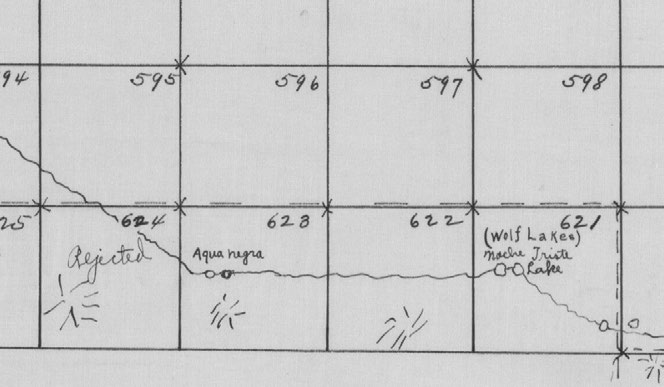
With no existing landmarks, the team continued building a series of mounds and four pits to mark league corners as they crossed Parmer County from north to south in just three days and entered Bailey County at the end of the day on May 30, 1880. At this point, Wiley mentioned the presence of living water two-and-a-half miles to the south-southeast, a location he called “Noche Triste,” which means “sad night” in Spanish. While this name does not survive today, it likely refers to the large basins along modern Blackwater Draw near Muleshoe, Texas, labeled on late nineteenth century maps as “Wolf Lakes.” An undated map in the GLO that closely corresponds to Wiley’s movements in Parmer and Bailey counties shows “Noche Triste Lake” with “Wolf Lakes” in parentheses. During this period and up to the 1920s, Blackwater Draw never ran dry as a tributary of the Brazos River, the headwaters of the North Fork Double Mountain Fork of that water course. The abundance of water along the Blackwater Draw attracted people for thousands of years before this survey, and it became the source of water for massive agricultural projects afterward.44
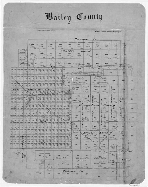
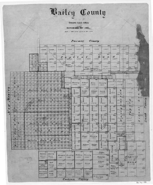
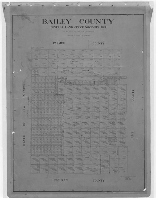
With work remaining in Parmer County, the crew moved 10,000 varas west in Bailey County beginning on June 2, 1880, before moving north again over the next two days. Generally careful to list landmarks and water features, it is notable that Wiley did not record the location of the namesake feature of the Blackwater Draw as he moved west along the north edge of the draw before leaving it. This feature, recorded on both nineteenth- and early twentieth-century maps as “Agua Negra,” Spanish for “black water,” is missing from his notes, but it appears on the map that also showed Noche Triste Lake. Agua Negra was recorded on maps of Bailey County in 1880, 1884, 1891, and 1913 (Fig. 4) at a location that corresponds to the present-day remnants of a large spring at a fork in the draw within Capitol League 628 in Bailey County.45
1884
1891
1913
Courtesy of the GLO Historic County Maps Collection provided by the Texas General Land Office to the Portal to Texas History, University of North Texas
Although unlabeled, the map that shows Noche Triste Lake (Fig. 5) undoubtedly tracks Wiley’s movements because it matches his notes almost perfectly. This map even makes note of features south of the large belt of sandhills that spanned the middle-north section of Bailey County. One of Wiley’s teams may have penetrated these sandhills to survey areas south because the map shows such a trail. The “Mackenzie Trail” is documented along with two lakes: “Monument Lake” and “El Coyote Lake.” For several years through the late 1870s, a large lake south of the sandhills in Bailey County appeared as “Agua Negra” on military maps, and it is on Charles Pressler’s paramount map of Texas from 1879. This twin-lobed lake was even the site of the U.S. Army camp of Capt. Philip Lee as he searched for Comanches and Apaches in April and May of 1877 following the skirmish between buffalo hunters and these bands at Yellow House Canyon. It is unmistakable in shape, so it is remarkable that Wiley would identify another feature north of the sandhills on his map as Agua Negra when what was previously known as Agua Negra lay south of these sandhills. Instead of using the name Agua Negra, Wiley’s map labels the large lake south of the sandhills as El Coyote Lake, the name it retains today. Indeed, ill-defined maps of Texas and New Mexico depicting the wagon route from Fort Sumner and Bosque Redondo to Central Texas contained a location called “El Coyote,” but it was nearly always shown south of the sandhills. For unknown reasons, the Wiley survey crew likely transposed the Agua Negra name to the location north of the sandhills while applying the El Coyote Lake name to the feature south of the sandhills. But Blackwater Draw has other names, including Eagle Springs Draw, Thompson’s Canyon, and Sod House Draw, all inspired by different sites along its path.46
Courtesy of the General Map Collection, Texas General Land Office
The work along the New Mexico state line occupied Wiley’s team for four days as they made a second and third pass through Parmer County. On June 2 and 3, 1880, they ran a north-south line roughly 15,000 varas from the state line. This line covered 45,000 varas of land near and along Catfish Creek as they crossed two tributaries of the creek. On June 4 and 5, the team ran a parallel north-south line 10,000 varas to the west of this line, crossing the same tributaries of Catfish Creek at different locations. On the night of June 4, the team camped at a playa that they found near the modern community of Farwell, Texas. While it is not entirely possible to pinpoint its location, it is likely one of the two playas that exist along the eastern boundary of Capitol League 549. On Saturday, June 5, they finished work in Parmer County and along the New Mexico border, crossing the Blackwater Draw and finishing that line in the northwest corner of Bailey County.47
Without taking time off, the Wiley crew began their final segment of work on Sunday, June 6, 1880, at a point in Bailey County northwest of Noche Triste Lake. From this location, they progressed in an easterly direction roughly following Blackwater Draw as it flowed east into Lamb County before it diverged from their path to flow south through the sandhills and toward Yellow House Canyon. Wiley continued to document and describe the quality and quantity of water in the Capitol Land Reservation, and it so happened that near and along the Blackwater Draw existed some of the most well-watered land in the region. Wiley moved east 5,000 varas from his previous corner and then diverted south 5,000 varas to cross the draw. Completing only 10,000 varas on this day, Wiley made specific efforts to note the location of two “living lakes” on the south line of his work. These lakes correspond to a chain of lakes near Muleshoe, with one lying one mile west of the city and the other on the outskirts of the western city limits. His men ceased work for the day near the southernmost of these lakes. They surveyed 5,000 varas east and then 5,000 varas north on the next day to rejoin the easterly line they intended to run north of Blackwater Draw.48
Aside from areas along and north of the Canadian River, this final stretch contained some of the best-described and documented land of Wiley’s survey. In addition to documenting lakes, creeks, and streams, Wiley also encountered two major roads on this segment, the first heading east toward the new settlements of Estacado and Mount Blanco and the other being a branch of the Fort Sumner Road and Comanche Trail that connected Central Texas to Fort Sumner, pueblos in New Mexico, and points beyond. This trail, known even then as the Trail of Living Water (owing to the abundance of springs along its route), provided groups with consistent water while they traversed the Llano Estacado. Wiley encountered eight lakes or empty basins during his work between June 7 and June 9, 1880, identifying three of them as “Mustang Lake,” “Laguna Lomita,” and “Alamocha.” Neither his notes nor his maps mention Spring Lake, which became one of the division headquarters of the XIT Ranch, even though his party’s route brought them close to its eventual location.49
On June 9, 1880, Wiley finished this east-west line of his work, which totaled 60,000 varas in length from its beginning in Bailey County, and he began the final survey segment that took him to the southeastern corner of Castro County. Wiley moved north 10,000 varas and then west 10,000 varas. These movements on June 9 and June 11 represent the last entries in Wiley’s field notes, and it is unclear if he surveyed the remaining land in Castro County or if he went south to survey the southern leagues in what became the Yellow House Division of the XIT Ranch in Hockley and Cochran counties. After Wiley’s involvement with the survey ended, it is not known what happened to him, but he did make a brief appearance in Denison in mid-July 1880. J.T. Munson, who left the surveying crew in mid-May, notified Governor Roberts on July 20 that the survey had concluded on July 3, and that his surveying crews arrived back in Denison on July 19. He declared that the surveyed territory was a “fine fertile body” that was “generally well-watered.” He added that his crews surveyed excess lands totaling sixty leagues to replace work rejected by Norton the previous year. In relaying this information to the Governor, Munson asked to be compensated for the extra work, a request that was summarily approved.50
Over the next month, Munson compiled the notes and information from his surveyors into a book of official field notes that describe each league of the Capitol Land Reservation in meticulous detail. Each page of this book was dedicated to an individual league, describing the boundaries of the survey, the corners of the survey, the county in which the league was located, and the main watershed connected to the league. Each survey contained 4,428 acres of land, or one league, unless specified otherwise. Each league was associated with a known monument or corner, and then a list of directions or calls traced its general shape. Most surveyed leagues were plain squares, but a rather large number were irregular polygons, especially if they abutted other surveys not included in the Capitol Land Reservation or lay on the Canadian River. An example of this irregular shape is Capitol League 278 along Trujillo Creek in Oldham County, which had twenty-eight sides enclosing its 4,428 acres. This maximized the use of vacant public lands adjacent to existing surveys but created an area that more resembled a gerrymandered political district than a surveyed tract. Coincidentally, Capitol League 278 abutted Gunter & Munson land that controlled the waters of Trujillo Creek and had been patented in 1879 just before the Capitol survey.51
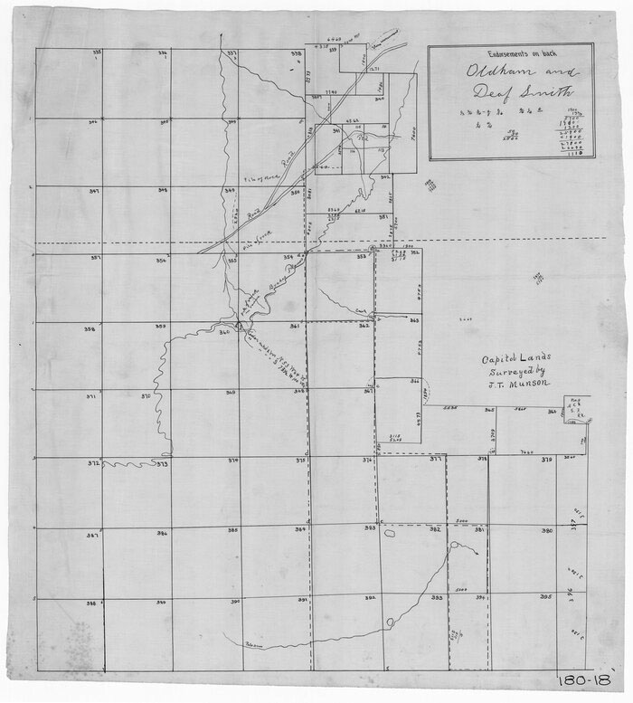
Completing the official field notes was done at Munson’s office in Denison. He used the notes and maps created by his teams. Munson’s reliance on Wiley’s notes is readily apparent. The official field notes for Capitol League 359 in Deaf Smith County mention two trees in proximity to a pile of rocks made at the southeast corner of that particular league. Munson states, “Thence 5,000 varas to pile of rocks in ravine from which cedar marked ‘x’ bears N53W 64 varas and another cedar marked ‘x’ bears S73°30’W 100 varas.” This reference appears on page 15 of Wiley’s notebook, and on the GLO map titled “Capitol Lands in Oldham and Deaf Smith counties” that shows the work of the survey party in that area (Fig. 6).52
Courtesy of the Twitchell Survey Records Collection, Texas General Land Office
Munson completed his field notes for 738 leagues of land on August 11, 1880. While a number of these leagues were later abandoned for reasons such as conflicts with other surveys, land quality issues that made them less desirable, or being surveyed in excess, Munson finished his work on time and submitted his field notes to the GLO under oath as required by law. The GLO’s responsibility was to confirm that the lands surveyed fell within the bounds of the available public domain and did not conflict with adjacent surveys. Along with Munson’s official field notes, Commissioner Norton submitted his evaluation of the survey. Norton described the swath of land as extending more than 197 miles from the northwest corner of the Panhandle, with an average width of more than twenty miles. He briefly discussed the abandoned leagues and an anomaly in Munson’s work that led to Capitol League 646 in Lamb County being omitted from his maps and notes. This omission did not cause any problems with the reservation, but its absence is still noted today on maps and surveys of Lamb County. Norton constructed a tabulated manifest for the Texas State Capitol Board to detail each league’s dominant features, including soil, topography, water, and for what purpose or adaptation the land was best suited. He also included general remarks about some leagues, denoting characteristics such as the types of grass present or describing drainage patterns. Norton gave this manifest to the Board on November 15. One day later, the Board accepted Munson’s and Norton’s work.53
The survey was not without errors or faults. The Capitol Building Commission solicited building plans for the new Capitol between November 20, 1880, and February 1, 1881, with submissions open just four days after Munson’s survey was approved. The plans of Elijah E. Myers were chosen on May 17, 1881, and bids for constructing the Capitol were open from July 1, 1881, through January 1, 1882. Two bids were received, and that from Mattheas Schnell of Illinois was approved and contracted on January 18, 1882. Through various transfers, Schnell abdicated his duties and the contract to Abner Taylor, Amos Charles “A. C.” Babcock, John V. Farwell, and Charles B. Farwell of Chicago, with Taylor eventually assuming the responsibility for the contract, with the remaining individuals acting as sureties. Babcock traveled to Texas to evaluate the Capitol Land Reservation to ascertain its true value and ensure the acreage was correct with as few discrepancies and major errors as possible, even though some were already known to exist. As part of his contractual obligations, Munson returned to the Capitol Building Commission a list of corrections to his work. He submitted two documents on November 12 and December 3, 1880. His corrections chiefly pertained to missing language regarding established corners of certain leagues, or corrections to inaccurately recorded measurements of boundaries that could be corrected by simply amending the field notes to reflect the proper dimensions.54
As closer examinations of the survey occurred, further errors became more evident. The largest of these resulted from the problematic placement of the northwestern corner of the Texas Panhandle. During the 1859 survey that dictated the boundary between Texas, New Mexico, and the Indian Territory, U.S. surveyor John H. Clark unilaterally established the northwest corner of Texas in the Panhandle at a point that lay more than two miles west of the 103rd meridian, the western boundary set by law. Clark’s error was not recognized until the spring of 1882, when William Spark “W. S.” Mabry, the new surveyor of the Oldham Land District, accompanied Babcock during his tour of the Capitol Land Reservation on behalf of his Chicago firm, which had the contract to build the new Texas Capitol. Mabry and Babcock left Tascosa on March 23. They made their way north to Buffalo Springs in Dallam County before initiating their search for the northwestern corner of the Panhandle, the launching point for J.T. Munson’s survey in 1879. Almost due west from Buffalo Springs, Mabry found a “nicely dressed” sandstone monument that was labeled as being constructed in 1881. It had markings that indicated that this was the junction of the 103rd meridian and latitude 36°30’. Believing that this location could not be Munson’s origin point, he proceeded roughly two miles further west before locating the 1859 Clark monument that Munson used to base his survey. It was evident that Munson used the 1859 monument because Mabry was able to identify Munson’s corners when using this marker as a reference. Mabry declined to choose which location was the true northwest corner of Texas, but he did write letters to Governor Roberts and C. B. Farwell to explain the quandary. The 1881 marker had been placed by U.S. surveyors Richard O. Chaney and William W. Smith when they surveyed in the Oklahoma Panhandle in October and November of that year, eighteen months after Munson completed his survey. Although the 1859 monument was the official northwest corner of Texas, its incorrect placement and Munson’s adherence to its location for originating his surveys gained Texas a swath of land west of the 103rd meridian totaling more than 600,000 acres when this location was upheld as the true boundary in later inquiries.55
As land began to be transferred to the Capitol Syndicate, as Babcock and his partners became known, the necessity to construct fence lines became clear. Mabry, once again tasked with surveying the boundaries of the Capitol Land Reservation, relayed to the Syndicate in January 1885 his concerns regarding the possibility that leagues abutting the 103rd meridian might be in New Mexico. He believed Texas still had a legitimate claim to this land beyond the 103rd meridian, but Mabry recommended that no XIT fences be constructed any further west than Clark’s marker due to the “unsettled question” of the true location of the 103rd.56 To locate the XIT fences, Mabry used Clark’s northwestern corner of Texas in conjunction with Clark’s other monuments along his 103rd meridian for the western edge of the XIT lands. Mabry found twelve of Clark’s boundary monuments between modern Dallam and Bailey counties, some of which he used to survey his fence lines. During this work in late 1884, Mabry discovered that Munson had miscalculated surveys for the western leagues on the 103rd meridian, finding that each of these crossed Clark’s boundary between Texas and New Mexico. Mabry resurveyed these leagues and found that this error resulted in 16,959 acres of land overlapping into New Mexico. He submitted this report to the GLO in December 1886 with a tabulation of how each league spilled into New Mexico. The overlap was the least egregious in the north, but the overlap became more severe as he went further south. Capitol League 1 in Dallam County had the least overlap, only eighteen acres, while Capitol League 594 in Bailey County had 723 of its 5,000 acres in New Mexico.57
In a January 16, 1885, report to the GLO, Mabry commented about another error with Wiley’s work that affected leagues in Oldham County. He referred to this later, in a December 1886 report as the “erroneous position of the northeast corner of league 304.” This is notable because it was the starting point for Wiley’s surveys in the Capitol Land Reservation. The origin of the error is unclear, but it likely arises from Wiley or Munson getting incorrect instructions on where the survey should connect to previously surveyed tracts. The first entry in Wiley’s field notes indicates that the league’s northeast corner should connect with the southeast corner of section number 43 of Block No. B5. This conflicts with Mabry’s correction in 1886 that connects the northeast corner of league 304 to the northeast corner of section 43 of Block No. B5, an error of one mile in distance. Since there is no written evidence of Norton, Wiley, or Munson’s orders from the State Capitol Board regarding where to begin their work in Oldham County, one can only presume that using the southeast corner of section 43 was erroneous. To correct this, Mabry began working to identify and reconstruct leagues affected by this error as well as locating more acreage to replace the land in New Mexico. He spent months in late 1886 carefully measuring and amending leagues in Oldham County based on a February 20, 1885, recommendation from the Board. Mabry also created additional leagues to make up the difference so that the Capitol Land Reservation contained the number of acres required by law.58
An additional error was found in December 1886 relating to Munson’s connection line between leagues in Lamb County. Since there was a belt of sandhills across Lamb County that was deemed unusable for the Capitol Land Reservation, Munson and his surveyors skipped a swath more than seven miles wide and surveyed better land further south in Lamb County before continuing into Hockley County. This area was separate from Capitol Land Reservation leagues in the northern counties, so Munson and his surveyors established a connection between the two areas to identify the land more easily. In Munson’s field notes submitted to the GLO, he made a specific reference to the connection as being between the northeastern corner of Capitol League 633 and a point 18,330 varas north and 1,180 varas west from the northeastern corner of Capitol League 618. When GLO representatives examined this survey, it was found that Munson erred in specifying Capitol League 618 when he should have written Capitol League 617.59
While this error appears insignificant, its correction resulted in a compression of leagues in Bailey County, which in turn affected some surveys completed and maps published soon after Munson finished his work. The earliest complete map of Bailey County from 1884 shows its eastern boundary as falling in the middle of Capitol leagues 583, 604, and 621, then extending south to its terminus at the northeast corner of Cochran County. Later maps place this eastern boundary one league further west in the middle of Capitol leagues 584, 603, and 622. This notably affected a block of land in western Bailey County patented to Melvin, Blum, and Blum, a real estate agency in Galveston, by putting a large number of their sections across the state line in New Mexico. As it was common practice to use previously established corners, the surveyor for Melvin, Blum, and Blum initiated his survey at the southwest corner of Capitol League 628. Although the locations of the Capitol league corners did not change when Munson corrected his aforementioned connection error, it did compress the area of Bailey County by one league as the numbering shifted eastward, which led to more than ninety-two sections of Melvin, Blum, and Blum land being in New Mexico.60
Such errors may have played a role in the preservation of Wiley’s field notes. The State of Texas in the 1920s sued some owners and trustees of XIT land — including George Findlay, Francis C. Farwell, and Hobart C. Chatfield-Taylor — to recover nearly 60,000 acres awarded to the Capitol building contractors. In Findlay v. State of Texas in 1921 and a subsequent appeal in 1923, courts ruled that the landowners were not entitled to land surveyed in excess by Munson despite tending the land for nearly four decades. The excess acreage was scattered in multiple surveys across the former reservation, so it was decreed that the State was to recover land from the last remaining large tract held by trustees of the former XIT Ranch and not from landowners whose property included excess acres. Wiley’s field notes were admitted as evidence to support the state’s case and were thus preserved in the Supreme Court of Texas files housed at the Texas State Library and Archives Commission.61
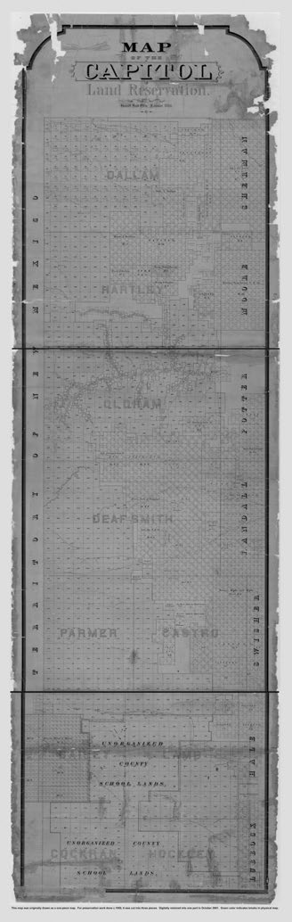
Courtesy of the General Map Collection, Texas General Land Office
The impact of the survey of the Capitol Land Reservation still resonates today. The league boundaries are still used to indicate land divisions in the region, with each league in the survey still bearing the numbering that Munson assigned. Several geographical features along the surveyors’ route were named in honor of crew members, but most have been forgotten. T. O. Plunkett and Wayland each had playas in Deaf Smith County named for them, but their names have not been on official maps of the county in almost a century. Likewise, Turnbo Spring in Bailey County was named for one of the Texas Rangers that escorted the surveyors, Lycurgus S. Turnbo, but this name is no longer used since the spring stopped flowing. Other reminders of the Munson survey exist, but his markers are rare. Some rock monuments may still exist in remote corners of the survey, but most of the corner monuments that the teams constructed have either been covered up, destroyed, or are unrecognizable.62
Munson is remembered most for the work of surveying the reservation, while others are forgotten. But he was largely absent from the bulk of the operation, having retreated to Denison while Wiley and others completed the work. There was no requirement for Munson to be present during the survey; he was merely the contractor and supervisor. He was ultimately responsible for the final product, but his crews did most of the work. Like Wiley, many disappeared without leaving another mark in the historical record. There is no list of the members of Munson’s crews, but a 1925 Frontier Times article names Wiley, Plunkett, Mack Park, and Harry Robinson, and it mentions that Munson’s second crew was led by “Mr. Wayland.” A newspaper article in July 1880 reported that George Cook also worked for Wiley, while Wiley’s field notes identify B. W. Dawson as a chainman.63 Despite being the most prominent name associated with the survey other than J.T. Munson, Wiley disappeared from history as quickly as he surfaced to work on the survey. The main problem is that he is identified only by his initials, “H. A.” So, while Munson has received historical attention for the survey of the Capitol Land Reservation, his crews, who made the greatest efforts to record and describe the vacant land that eventually became the XIT Ranch, have gone largely unnoticed. That is sad because, despite the legal conflicts and errors in their work, they all deserve credit for providing essential information in the process of building a new Texas Capitol and preparing a large portion of the Panhandle for future settlement.